A modern-day forgery —
“There is no reasonable doubt here. This new analysis should put the matter to rest.”
Jennifer Ouellette
–

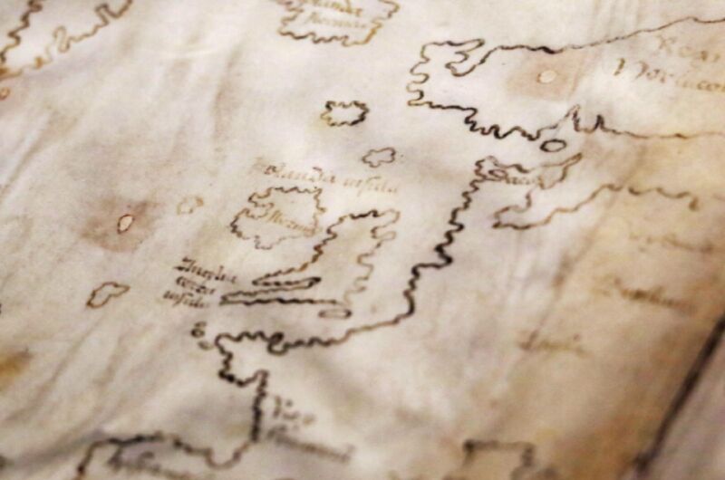
Enlarge / The Vinland Map purports to be a 15th-century map with a pre-Columbian depiction of the North American Coast. A new analysis has confirmed that the map is, in fact, a modern-day forgery.
Scholars have questioned the authenticity of a purported 15th-century map housed in Yale University’s Beinecke Rare Book & Manuscript Library since it was first unveiled to the public in 1965. About the size of a placemat, the Vinland Map is an intriguing document because, in addition to Africa, Asia, and Europe, the map depicts a section of the North American coastline identified as “Vinlandia Insula” just southwest of Greenland. This suggested that Norsemen may have been the first Europeans to discover the Americas, well before the first voyage of Christopher Columbus. But evidence that the map is a hoax has been steadily accumulating, particularly over the last few years. And the latest scientific analysis has definitively put an end to the controversy once and for all: the inks used to draw the map are of modern origin.
“The Vinland Map is a fake,” said Raymond Clemens, curator of early books and manuscripts at the Beinecke. “There is no reasonable doubt here. This new analysis should put the matter to rest.”
The map first came to light in 1957, when a London book dealer named Irving Davis initially offered the Vinland Map—then bound together with a medieval text, Hystoria Tartarorum—to the British Museum, acting on behalf of another European dealer named Enzo Ferrajoli de Ry. (It was later discovered that Ferrajoli had been convicted of possessing stolen manuscripts in the 1950s.) But the museum’s Keeper of Manuscripts thought the handwriting style showed elements that weren’t common until the 19th century and passed on the offer, suspecting a forgery.
An American dealer, Laurence C. Witten III, ended up purchasing the volume for $3,500 and offered to sell it in turn to Yale (his alma mater) for $300,000. The price was a bit steep for the university, but another alumnus agreed to purchase the map and donate it to Yale, provided its authenticity was confirmed.
Wormholes
The map’s existence was kept secret for several years as a handful of scholars examined the artifact in detail, all while writing a book about their findings. There was good reason to be suspicious: while both the map and the Hystoria were dotted with wormholes, those wormholes didn’t line up with each other. And Witten was reluctant to reveal the map’s provenance, possibly because of tax concerns.
But the following year, Davis sold Yale another medieval tome, the Speculum Historiale, which also had wormholes—and those wormholes did line up with the Vinland Map. Clearly, all three books had been bound together into a single volume at some point. Since both the Hystoria and Speculum were genuine, it seemed more likely that the Vinland Map was genuine as well. Further encouragement came with the discovery of a Norse archaeological site in 1960 at L’Anse aux Meadows on the northern tip of the island of Newfoundland—the only confirmed Norse settlement in or near North America outside of Greenland.

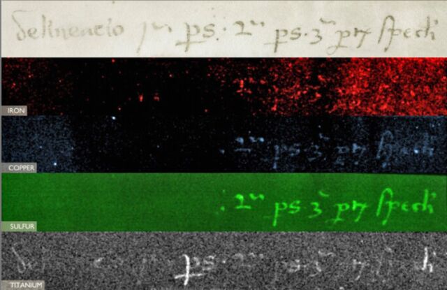
Enlarge / An inscription on the back of the map (top) was overwritten in an apparent attempt to deceive. The bottom image shows the presence of titanium in the ink, which strongly suggests a modern origin.
Yale publicly announced its acquisition of the Vinland Map just before Columbus Day in 1965. Experts questioned its authenticity almost immediately and even held a conference at the Smithsonian Institution the following year. Among other criticisms, no scientists had been allowed to examine the map since 1957. Radiocarbon dating done in 1995 found that the parchment, at least, was genuine and likely originated between 1423 and 1445. But in addition to the handwriting concerns, the British Museum’s experts had noted peculiarities about the inks used to create the Vinland Map. The experts found no trace of the iron-gall ink used in the two books with which it had been bound, and they couldn’t identify the recipes.
That was a task for science, and science obliged in 1972. That’s when forensic specialist Walter McCrone conducted a number of chemical analyses on the inks. He found that the map’s yellowish lines—beneath nearly vanished black lines—contained titanium dioxide (anatase) in a form that wasn’t manufactured until the 1920s. Only trace amounts of iron were in the ink. The titanium finding was called into question in the early 1980s, when scientists at the University of California, Davis studied the map with Particle-Induced X-ray Emission (PIXE) and found only trace amounts—the first time the PIXE technique had been used for ink analysis. However, subsequent PIXE data gleaned over the ensuing decades cumulatively demonstrated that the discrepancy was due to errors in the UC-Davis team’s work.
Yale declined to weigh in on the controversy while all the various examinations were being done, although Yale historian Paul Freedman said during a 2011 lecture that he thought the Vinland Map “was unfortunately a fake.” By 2018, Richard Hark, a conservation scientist at Yale, had conducted a new global chemical analyses and also found anatase, concluding the ink was modern. At this point, it seemed fairly certain that the document was a fake.
More X-rays
This latest chemical analyses by Yale is notable because they are the first complete examination of the entire document’s composition of elements, using tools and techniques not available previously. Yale University conservators Marie-France Lemay and Paula Zyats worked with scientists in Yale’s Institute for the Preservation of Cultural Heritage on the various experiments. They subjected the ink to X-ray fluorescence spectroscopy to identify how various elements were distributed throughout the map. That gave the team a “big picture” data set, rather than focusing on individual points.

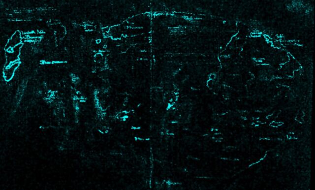
Enlarge / Macro X-ray fluorescence spectroscopy (XRF) revealed the presence of titanium throughout the map’s lines and text.
The conservators found no sign of iron, sulfur, or copper, which would be typical of a medieval iron-gall ink. As for the Vinland Insula portion of the map, there were high levels of titanium and small amounts of barium, consistent with commercially manufactured white pigments in the 1920s. For comparison, the team also analyzed the inks used in 50 15th-century medieval manuscripts in the Beinecke’s collection, all containing significantly lower amounts of titanium than the inks used to draw the map, as well as much higher levels of iron. A follow-up analysis using field emission scanning electron microscopy (FE-SEM) ruled out the possibility that the anatase could be naturally occurring.
So the Vinland Map is most definitely a modern forgery—and probably a deliberate one. According to Hark, an inscription on the back of the map appears to have been a bookbinder’s note on how to put together the original Speculum manuscript. But it was written over with modern ink. “The altered inscription certainly seems like an attempt to make people believe the map was created at the same time as the Speculum Historiale,” said Clemens. “It’s powerful evidence that this is a forgery, not an innocent creation by a third party that was co-opted by someone else, although it doesn’t tell us who perpetrated the deception.”
The team also examined the Speculum and Hystoria medieval texts. Radiocarbon dating showed those texts dated back to between 1400 and 1460, in keeping with the parchment used to create the Vinland Map. So the forger seems to have used empty pages from a genuine 15th-century manuscript to create the map. One leaf of the Speculum had the watermark of a paper mill in Basel, Switzerland, and the texts of both the Speculum and Hystoria look like the handwriting of the same scribe. Apparently, the two volumes were often bound together, per Zyats, as evidenced by the recent discovery of a 14th-century copy of the Speculum with a copy of the Hystoria bound in its final volume.
Clemens expressed relief that the question of authenticity (or lack thereof) of the Vinland Map has finally been settled. “Objects like the Vinland Map soak up a lot of intellectual air space,” he said. “We don’t want this to continue to be a controversy. There are so many fun and fascinating things that we ought to be examining that can actually tell us something about exploration and travel in the medieval world.”

