A Dry and Dusty land —
Chamise is kind of a crystal ball for understanding how badly California might burn.
Matt Simon, wired.com
–
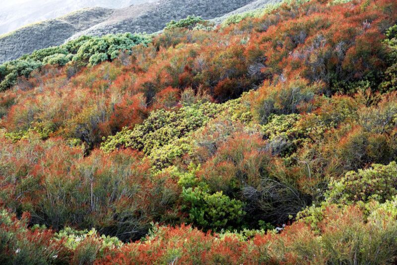
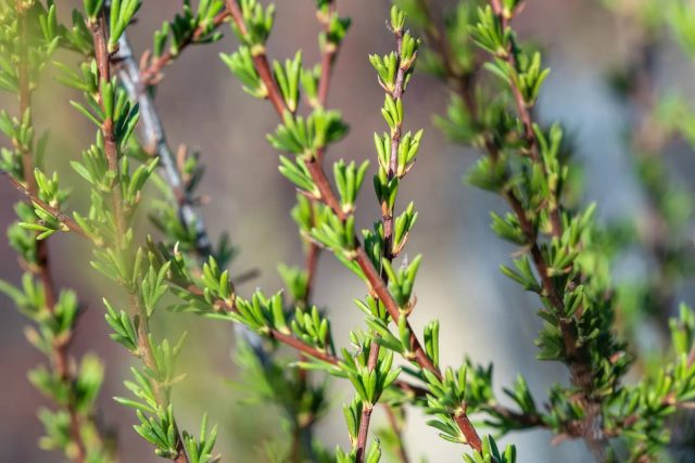
If you’re kind of judgmental when it comes to plants, you might describe the chamise plant as “meh.” Technically it’s a shrub, which in the hierarchy of plant types barely outranks a weed. Chamise grows up to a dozen feet tall and sprouts needle-like leaves less than a half-inch long, making it look like overgrown rosemary. Only it doesn’t really smell, even though it’s a member of the rose family.
Appearances and scents aside, chamise turns out to be a fascinating plant, one critical not only to the California landscape but to the safety of its human residents. When fire scientists want to know how flammable the state’s vegetation might be, they don’t rely on some newfangled gadget. They rely on chamise. “It’s a really pretty and kind of understated shrub,” says Bryant Baker, conservation director of the Los Padres ForestWatch, which advocates for the protection of California’s habitats. “And I think because it’s so common, it’s often taken for granted.”
But Californians ignore it at their peril, because it is an excellent indicator of how dry the whole landscape is getting. Chamise dominates native chaparral ecosystems up and down the state, dense shrublands that are too arid for trees. (This is a Mediterranean climate, after all, in which rain stops in the spring and doesn’t restart until autumn.) But the chamise is beautifully adapted to ride out the baking heat: those tiny, leathery leaves have far less surface area than a broadleaf, so they don’t lose as much moisture. “These plants are adapted to go for many months without a single drop of water, which is pretty amazing,” says Baker. “You don’t usually find that outside of desert areas.”
Bryant Baker, Los Padres ForestWatch

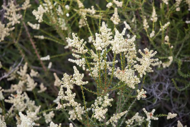
Come summer, the chamise blooms into a mass of small white flowers. These attract insect pollinators, which in turn attract birds—so from the plant a complex ecosystem unfurls. When the flowers start to dry out in the summer heat, they turn a sort of rusty orange. “This can give the appearance that chaparral dominated by chamise is brown and dying, but it’s completely normal,” says Baker. “It also makes for some wonderful contrast across the landscape in the late summer and fall.”
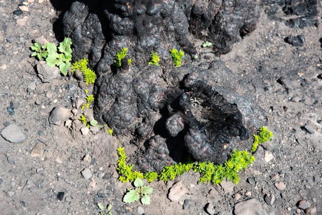
Before humans arrived in California, the chaparral only burned periodically, for instance when a thunderstorm rolled through, creating lightning but no rain to drench any ignitions. For this, too, the chamise was well adapted. An intense fire will pretty much obliterate the shrub, leaving only charred stems behind. But the chamise hasn’t given up yet. At its base is a structure known as a burl, which hides growing buds that have been shielded from the fire. Just a few months after a blaze, little bits of green will start growing across the charred earth. “It is remarkable in its ability to resprout after a fire,” Baker says.
Bryant Baker, Los Padres ForestWatch
But fire scientists aren’t so much interested in the regenerative abilities of the chamise as its powers of prognostication. Because the plant is so abundant, it’s a sort of standardized species—they can sample it all over the state. Fire weather researchers like San Jose State University’s Craig Clements (who’s also a fire chaser) use it to get an idea of how parched vegetation is overall. Clements goes out into the field, randomly samples chamise plants, and takes the material back to the lab. He weighs it, pops it in an oven for 24 hours at 212 degrees Fahrenheit, and then weighs it again to determine how much water it’s lost. Or, put another way, he measures how much moisture the shrub had in the first place.
And nothing scares a fire weather scientist quite like a year with dehydrated chamise. If it’s dry, then that’s a good indicator that everything is dry. “Right now, these are the lowest April 1 fuel moistures we’ve ever had,” Clements says. This is supposed to be the time of year when moisture levels are at their highest, thanks to recent autumn and winter rains. But California is withering in a drought. “The shocking thing in 2021 is that we don’t have any new growth on chamise in our sample areas,” Clements says. “These plants are stunted by the drought.”
Bryant Baker, Los Padres ForestWatch
The California landscape appears ready to burn epically this year. “It looks bad, to put not too fine a point on it,” says UC Los Angeles climate scientist Daniel Swain, especially considering that several wildfires have already broken out in heavily forested parts of Northern California. “It shouldn’t be dry enough to support accidental fire ignitions in April in the Santa Cruz Mountains.”
“I think the forest fire risk this year is going to be about as high as it can be,” Swain adds. “And that’s pretty alarming considering what we’ve seen in the last couple of years.”
In 2019, the Kincade Fire burned nearly 80,000 acres north of San Francisco, and in 2020, a rare summer storm sparked hundreds of blazes that blanketed Northern California in smoke. “This year, with the lack of rain and the amount of dead fuel that’s still remaining from the years and years of drought, California is still receptive to another equal, if not worse, fire season than we saw last year,” says Jon Heggie, battalion chief of the California Department of Forestry and Fire Protection, also known as CalFire.
With vegetation already so desiccated, accidental ignitions can turn into big blazes. But the worst of the state’s fire season doesn’t typically arrive until autumn, when seasonal winds tear through, driving wildfires at incredible speeds. This is what made the Camp Fire of 2018 so deadly: winds accelerated the conflagration through critically dry vegetation so quickly that many in the town of Paradise couldn’t escape. Eighty-five people died.
Bryant Baker, Los Padres ForestWatch
There’s a frustrating and often tragic aspect to fire science and predicting the likelihood of ignitions: researchers like Clements can use chamise and atmospheric modeling to warn when conditions will be ripe for an out-of-control blaze in California, but they can’t say where it’ll break out. In 2018, Clement says, dry fuel and forecasted strong winds told him the fire risk was very high just before the Camp Fire. “I knew the day before there was going to be a bad fire,” he says. “We just didn’t know where it was going to be.”
The power company Pacific Gas & Electric later pleaded guilty in court on involuntary manslaughter charges relating to the fire, admitting that its equipment had sparked it. According to the Los Angeles Times, the utility had the option to initiate what’s known as a public safety power shutoff, or PSPS, to de-energize that equipment but did not do so. PG&E has since committed to improving that PSPS program.
Part of what informs the PSPS decision is the forecast for wind and humidity. But the other part is chamise: PG&E crews sample the plant from sites across Northern California. All this data goes into a fire potential index, or FPI, that the utility’s staff calculates every day, forecasting three days out for its territories. “Our FPI is actually pretty sensitive to changes in live fuel moisture,” says Richard Bagley, senior PG&E meteorologist. “That’s how it’s really important to us to get that piece of the puzzle right.”
Climate change, of course, is complicating that puzzle, making California’s wildfire crisis all the worse. The rains are arriving later in the year, meaning there’s more time for seasonal winds to drive fires across a landscape that’s been dehydrating since spring. And generally speaking, a hotter, drier atmosphere sucks more water out of plants. Chamise, then, is telling the story of a state struggling with climactic upheaval. “If you think about climate change and wildfire, it’s all about fuel moisture,” Clements says. “We’re getting drier, so we’re pulling more moisture out of these plants and driving lower soil moistures.”
“Fingerprints of climate change,” Clements adds, “are all over it.”
This story originally appeared on wired.com.

